
- Program Type: Guided Trekking
- Duration: 16 Nights 17 Days
- Region: Kinnaur, Spiti and Parvati Valley
- Altitude: Pin Bhabha Pass – 5020 m, Pin Parvati Pass – 5400 m
- Grade: Challenging
- Group Size: 8 – 12 pax
- Starting Point: Kafnu, Kinnaur, HP
- Ending Point: Barshaini, Kullu, HP
- Total Trekking distance: 151 km

Double Crossing: Pin Bhabha Pass (4890 m) and Pin Parvati Pass (5319 m) - Trek From Kinnaur to Spiti to Kullu-Manali
17 Nights18 Days Shimla
₹74,500.00 + 5% GST
Kinnaur to Spiti to Kullu Trek: Pin Bhabha (4890 m) and Pin Parvati Pass (5319 m)
I once heard somewhere....”You do not climb a mountain. If you are lucky, it allows you to stand on it.” If this is the humbling thought one has, the challenge that double passing may pose, can be navigated with ease. We are using the term Double Passing as the idea of this expedition is to first cross the Pin Bhabha Pass and after a tuning in to the challenging terrain, better navigate the Pin Parvati Pass. There can absolutely be no comparison between the Pin Bhabha Pass and the Pin Parvati Pass. Except for the fact that they are both challenging cross-over treks with breathtaking views, there is not much common in them. The essence of this Double Passing trek lies in its name. The challenge lies in attempting to cross the two high altitude passes in the same expedition. The trek to Pin Bhabha Pass and Pin Parvati Pass are challenging and requires a high level of fitness, endurance, skill and discipline for crossing these two passes back to back. Pin Bhabha pass is a cross over pass from Kinnaur Valley to Spiti Valley and Pin Parvati pass is a cross over from Spiti Valley to Parvati Valley. The starting point of this trek is in Kafnu, which lies in the lush green Kinnaur and we cross over from Pin Bhabha pass and end at Kaza in Spiti. The trail to Pin Parvati pass starts in Kaza, which is in Spiti and ends in Barshaini which is in Parvati Valley. The terrain changes from lush green Kinnaur to the moraine and scree of Spiti and then again the lush green Parvati. The Bhabha valley lies next to, but not strictly within, the trans-Himalayan terrain and its average rainfall is higher than in other parts of Spiti. There is a wealth of flora and fauna here and has been a subject of many researches. Pin Valley National Park was also established in 1990 to protect the Ibex which are found here in great numbers.

This trek joins the trail from Pin Parvati valleys which can be followed either way. Pin Parvati Pass is considered to be a challenging and the most scenic trails to trek on. In earlier times, it was difficult to access the trans-Himalayan valleys of Spiti as they were surrounded by the Tibetan plateau on one side and high passes of the norths which were closed for most part of the year. This high pass was first crossed in 1884 by Louis Dane. This route was opened to trekkers in 1993. After crossing the Pin Bhabha Pass, we will rest for a day in Mudh. This will also be the rendezvous for people who wish to join for crossing just the Pin Parvati Pass. Others, after freshening up in Mudh, will continue to cross the Pin Parvati Pass. The trek will start from Kafnu near Shimla and will finally end in Barshaini.
TRIP FACTS
Highlights
- Cross 2 high altitude passes
- Witness the grandeur of Kinnaur and Kullu Valleys
- High altitude desert landscape of Spiti Valley
- Latest Equipment and all climbing gear
- Climb with locals for an authentic experience
- Impeccable Safety Record
Detailed Itinerary
DAY 01: MEET IN SHIMLA AND DRIVE TO KAFNU
- Maximum Altitude: 7,878 ft
- Duration: 6 – 7 hours drive from Shimla
- Distance from Shimla: 205 km
Kafnu is a small village near Shimla and can be accessed by road from Shimla. It is well connected from Rampur, Karcham, Kalpa and Recong Peo. River Bhabha runs through Kafnu and the hydroelectric power project here makes it very accessible by road. The drive from Shimla takes about 6 – 7 hours and all trekkers are requested to meet us there.
Arrangements for the stay overnight at Kafnu will be made by us and the day should be wisely used to rest and prepare for the trek to Mulling the next day.
KAFNU TO MULLING
- Maximum Altitude: 10,637 ft
- Duration: 8 hours
- Trek Distance: 11.3 km
- Trek gradient: Moderate
The trail starting from Kafnu is exquisite and beautiful. The trail meanders through a thick coniferous forest.
The trek starts from Kafnu and can be a challenging day. After a short trek from the village, we will come across India’s first underground dam, the ‘Bhabha Hydro Project‘. We will continue to walk for almost 3 km on a motorable road.
After crossing over to the left bank of River Bhabha, we will take the narrow route going up from the road. Continue to walk along this route for 4.4 km. Here the flora is very thick and rich in silver birch, oak and pine trees. A flat 1 km walk from here, will lead to a green clearing.
After walking for about 7 km, we will reach a campsite called Champoria, which is at an altitude of 9,491 ft. From here, we will cross over to the right bank of River Bhabha using a log bridge.
We will walk along the river bank and spot a tributary of River Bhabha. From here, pace yourself for the ascent and we will reach Jhandi top which is at an altitude of 10,640 ft. Take a short break here and soak in the sights. The Mulling hut and campsite is visible from here. A short hike of about a kilometer will get us to the campsite. This is a beautiful spot to camp overnight.
MULLING TO KARAH
- Maximum Altitude: 11,653 ft
- Duration: 5 hours
- Trek Distance: 6 km
- Trek gradient: Moderate
The trail we follow today starts with a gradual ascent through a rocky terrain. Water source is a scarcity and it is recommended to carry water. After a trek of about 1 km, there is a gradual ascent of about 2 km to witness a unique geographical phenomenon called a “subterranean river”. You will hear a river flowing but can’t see it. The river flows underneath the surface here. From this section, it’s a 1.5 km steep ascent to the top to reach a lush green meadow full of flowers.
After crossing the meadow and walking for another kilometer, we will reach the campsite near a water stream. There is a beautiful lake nearby and we can set up camp at Karah.
TREK FROM KARAH TO PHUSTIRANG
- Maximum Altitude: 13,474 ft
- Duration: 4 hours
- Trek Distance: 4.91 km
- Trek gradient: Moderate.
Today we will trek just 4.91 km and it is the shortest day of the entire trek but involves steep ascent. After crossing the tributary of River Bhabha, we will climb the steep slope. The terrain here is a combination of mud a loose stone and it is recommended to tread slowly and carefully. The trail has many streams and humps that need to be traversed. After climbing for about 4 km, we will reach a campsite set up near lower Phustirang. From here, continue the upward climb for another 700 meters and you will reach Phustirang.
From Phustirang, you can clearly view 3 mountain passes: Nimish Khango (16,185 feet), Tari Khango (17,318 feet) and Pin Bhaba Pass a.k.a Wang Khango (16,105 feet). We will camp here overnight.
ACCLIMATIZATION AND REST DAY AT PHUSTIRANG
Let’s make sure we get it right. We will spend a day here to acclimatize and rest.
PHUSTIRANG TO MANGRUNGSE VIA PIN BHABA PASS
- Maximum Altitude: 16,105 ft
- Duration: 9 hours
- Trek Distance: 10.9 km
- Trek gradient: Difficult.
Today, we will ascend steep slopes and cross high passes connecting the Pin and Bhabha Valley.
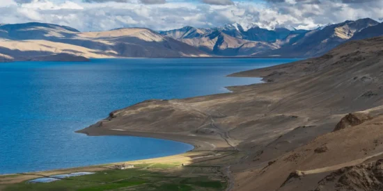
From the highest point between the mountain valley (Saddle point of the Pass), there is a paradigm shift in landscape. There are pronounced geographical distinctions. Lush green grasslands of Bhabha valley give way to desert mountain valleys of Pin. The combination of scree , moraine and glacier make the descent steep and tricky to traverse. It is advised to descend with great caution and care.
After descending for about 2 km, River Pin can be clearly seen. After crossing the river to the right, it is a gradual descent but embedded with moraine and scree. Hence, caution is advised. After about 5 km from crossing the river, we can see the Mangrungse campsite where we will camp overnight. Tia campsite is across the river bank. There is a mountain stream nearby and the beautiful mountains of Spiti offer a sight to behold, with the River Pin nearby.
TREK FROM MANGRUNGSE TO MUDH
- Maximum Altitude: 13,674 ft
- Duration: 7 hours
- Trek Distance; 16.29 km
- Trek gradient: Moderate – difficult
It is a long 16.29 km stretch to Mudh that we will trek today, so an early start is advised. We will ascend from Mangrungse on to the trail and continue walking on it. Mangrungse and Bara Boulder are separated by a distance of 4 km and the gradual descent is full of boulders and scree.
The tributary of Pin River is about 300 mts from Bara Boulder. We will cross this stream using a log bridge. The trail from here is flat and is predominantly made up of red stones and red soil. A short walk from Bara Boulder will take us to the banks of a mountain stream. After crossing the stream using a log bridge, we will reach a flat stretch of land from where Mudh village is visible.
We will have to cross River Pin using a suspension bridge to reach Mudh. After crossing the river, it is a short ascent to the village.
REST DAY. CHILL IN MUDH (VISIT KAZA)
Mudh is a picture perfect village with terraced fields of peas and barley. You can camp and relax here and take in the beauty of Mudh. Or, you can choose to visit Kaza, Ki and Kibber, for which cabs can be arranged (on prior notice and additional cost) to ensure your timely return to Mudh. This is also the starting point of the trek to Pin Parvati Pass. Trekkers who wish to join us for the Pin Parvati Pass can meet us at Mudh.
TREK FROM MUDH TO TIA
- Maximum Altitude: 12,795 ft
- Duration: 2 hours drive + 2-3 hours trek
- Trek gradient: Moderate.
We will leave for Tia early in the morning which will take about 2 to 3 hours. It is a gradual ascent on screen and shale (granite rocks) surrounded by barren mountains of Spiti. The trail is quite well defined.
We will trek upstream the River Pin. The trail is at a higher level than the river. However, to set up camp at Tia, we will have to descend to the river bed. There is a scarcity of level ground to set up camp. Mangrungse is on the other side of the river now.
TIA TO SHIA
- Maximum Altitude: 14,763 ft
- Duration: 5-6 hours
- Trek gradient: Difficult.
On the trail today, we will have to cross many glacial streams so an early start is recommended. The trail on the left bank of the River Pin is full of loose sedimentary rocks. Then, we will descend to the river and after crossing it, ascend from here. After trekking for some time, Pin glacier is visible, looming high up.
Shia is a shepherd’s campsite with not enough space for camping. Camping spots can be found between rocks and shale. We will have to be careful as it is a landslide prone area.
SHIA TO PIN BASE CAMP
- Maximum Altitude: 15,780 ft
- Duration: 5-6 hours
- Trek gradient: Difficult.
We will cross the River Pin and start the steep ascent to Pin Base Camp. It is a steep ascent of 1,700 ft. We will rope up and cross a stream which comes from the Pin glacier. We will camp at the Pin Base Camp which is rocky and is below the Pin glacier and 1,000 ft below the pass.
The campsite is very windy with rugged mountains on all sides.
PIN BASE CAMP TO MANTALAI OVER PIN PARVATI PASS
- Maximum Altitude: 17,457 ft
- Duration: 12 hours
- Trek gradient: Difficult
Ideally, any high-altitude mountain pass should be crossed early in the day and before noon as the weather can be tricky. The ascent to the Pass is tough as we will gain altitude and the glacier is at an inclination. We will not come across any crevasses on the Pin side of the pass. The older and the original Pass is visible on the left side of the ridge while the Pass used these days is at a higher plane.
The view from Pin Parvati Pass is breathtaking and will be with you forever. We will be able to clearly see Parvati South Ridge, Snow Peak, Ridge Peak, Pyramid Peak, Kullu Makalu, Bara Shigri, Kinner Kailash and Shrikhand Mahadev, if we are lucky. The views of Kinnaur, Kullu and Spiti valley at once can be almost overwhelming. Mantalai campsite can also be spotted far below the Pass.
DAY 13: REST DAY AT MANTALAI LAKE
Day for Rest and Acclimatization
MANTALAI LAKE TO ODI THACH CAMPSITE
- Maximum Altitude: 13,440 ft
- Duration: 4 hours
- Trek gradient: Moderate.
Today, we will trek a scenic downhill to the beautiful meadows of Odi Thach. Continue walking along the right side of the river and up to a moraine-filled ridge. From here, we can see the point from where the River Parvati emerges. Today is a relatively easier day to walk as it is in a valley. Follow the trail on the right side of the valley till you reach a large ridge breached from the right side from where the River Parvati rushes down towards Mantalai. After we cross the first series of fridges, we will finally leave the Mantalai region.
The route towards Odi Thach meanders towards the left side of the valley. We will see slopes full of red, purple and blue flowers. The swamp land opens to a plateau and then goes through boulders till we reach the level meadows of Odi Thach. A little ahead of Odi Thach is Jwari Thach where we will camp.
ODI THACH TO TUNDA BHUJ
- Maximum Altitude: 12,517 ft
- Duration: 8 hours
- Trek gradient: Difficult.
The trail starts from the meadows of Odi Thach and goes lower to the River Parvati. There are many waterfalls to the right and the River Parvati to the left. Mt Kullu Eiger is clearly visible in front of you to your left along with some unnamed peaks and glaciers surrounding the valley. Then, we will descend down to Pandu Pul which is a natural bridge over the river formed by large, misshapen boulders.
After this, we will descend another rock jutting out on a tributary of River Parvati. Be very careful, as we will negotiate some narrow ledges on the river. The pulley that takes you to Thakur Kuan is broken so you will have to stay on the same side of the river. This trail gets tricky as it is overhanging the swollen Parvati River in many places. Once the tricky patch gets over, we will enter a forest full of rhododendrons and pine trees.
Tunda Bhuj campsite is surrounded by cliff faces, higher up from the river. There are many waterfalls on these cliff faces. Pin Parvati is an experience that gets better and better after each campsite as the views get incredible and greener all the while running along the River Parvati.
TUNDA BHUJ TO KHEERGANGA
- Maximum Altitude: 10,499 ft
- Duration: 4 hours
- Trek gradient: Moderate.
Today’s trek to Kheerganga is a steady descent to the gorge below the Parvati River. The trail meanders through pasture lands full of silver birch trees.
The trek starts with crossing the bridge over a tributary of the Parvati River. The trail unwinds downhill, out of the expanses of Parvati Valley to open pasture land.
Watch your step as it can get slippery with all the mud. After some time, you will enter pastures again. On your right, you will see local shepherds.
Ahead is a bridge that we will cross. After about 25 minutes of hiking from here, the trail curves towards the left. This is the first of many dhabas you will find near Kheerganga.
From the pasture land, there is a meandering descent down to the forest for 30 minutes that exits into another small open pasture land. From here, you descend down to the stream and crossover the last tributary over a makeshift bridge. The trail ascends from the stream for about 45-50 minutes followed by a series of gradual inclines and declines towards Kheerganga.
You will reach Kheerganga by afternoon and this is, frankly, one of the shorter days of the trek.
Kheerganga is your last campsite and it feels like the end of the trek. There are many cafes in Kheerganga and we will pitch our tents here. You can also take a bath in the hot springs of Kheerganga, which is a five-star sauna experience at the end of a long, tough trek. It is quite a luxury after a strenuous and a double-passing trek like Bhabha Pass and Pin Parvati Pass!
KHEERGANGA TO BARSHAINI; DRIVE TO MANALI
- Maximum Altitude: 9,120 ft
- Duration: 3 hours walk
- Trek gradient: Moderate.
We will now trek for 7 km from Kheerganga to Barshaini. The trail from Kheerganga meanders through thick forests and is muddy. Caution needs to be practised on this descent. There are many dhabas on the trail. We will cross a makeshift bridge over River Parvati, which is ferocious now.
After crossing the bridge, we will reach Rudranag. There is a Shiva temple here. After walking uphill and downhill for about an hour, we will reach Nakthan village. After a steep descent from here, we will finally reach an open meadow called Swagani Maidan.
CELEBRATIONS IN OLD MANALI BEFORE DEPARTURE
After a rigorous time spent crossing two mighty passes: Time to celebrate and Enjoy Great Food.
Arrangements would be made to drop guests to the Volvo bus stand
Buffer Day: Rest days are extra days in case the weather gets unfavourable
Inclusions
- Stay in comfortable tents during the trek on triple sharing.
- All Meals included – Starting from Lunch on day-1 to breakfast on day-18 (veg/non-veg freshly cooked)
- Services of experienced MOI/ BMC qualified lead guide and qualified assistant guide.
- Kitchen equipment, high altitude cook, porters and ponies and all the camping arrangements.
- Wildlife/ environmental permits and other permits & levies.
- All transportation as per itinerary in local cars/jeeps in Simla and Manali
- First-aid medication, oxygen cylinder and all emergency backups.
- ‘ Leave No Traces’ protocol charges.
Exclusions
Cost of travel to and from your city.
Cost of any form of insurance (Personal/Baggage/Medical)
Cost of rescue, evacuation, hospitalization, etc.
Any expenses of personal nature like personal food, tips to drivers, guides, any beverages etc.
Any expenses that arise due to changes in itinerary and increase in no. of days because of natural forces like landslides, weather, roadblocks, flight cancellations, sickness etc.
Porterage for your personal bags
Additional Activities
- All participants are recommended to have travel insurance that covers trekking and wilderness travel.
- Trekking programs in the Himalayas do not necessarily always run exactly as scheduled. Allow for unplanned long days or early camps due to weather disruptions or similar causes.
- Wear shoes and clothes you are comfortable in and do not forget waterproof jackets and warm clothing.
- Do not litter the environment. Polythene and plastics are non-biodegradable and unhealthy for the environment and must not be littered or burned and should be carried back.
- (complete details with all that you need to know and get shall be shared with you after you have booked the trek)
Items to Carry
Clothing
- Backpack 40 – 50 Lt. with rain cover.
- B. Day Pack 15 – 20 Lt. -To carry your personal gear,camera, water bottle, trail clothing, packed food etc. (you will need this, when you offload your larger pack onto a horse/porter)
- Trekking Shoes: Please do not wear sports shoes as on most treks as we go higher it gets harder to use the sports shoes. We recommend shoes with a good hard sole and also ankle support preferable waterproof. While we do not subscribe to any particular brand you can try the Quechua Forclaz 600 or like.
- Socks:
2-3 pairs of cotton socks
1-2 pairs of woolen socks (best to use when in camp. Not recommended while trekking). - Clothing:
Pants: 2-3 pairs -Ideal are quick dry lightweight synthetic pants. Alternatively track pants are also comfortable to trek in. Avoid jeans/denims.
T-shirts 2-3 pairs–Preferably full sleeves
Synthetic Fleece Jacket -1 pair.
Wind proof/ Water proof Jacket -1 pair. - Down filled / Hollow fiber fill insulated Jacket – 1 pair (optional-get this if you want to stay extra warm at camps.)
- A woolen cap for the head and ears
Thermal liners-1 pair upper and lower
Miscellaneous
- Toiletries -Sunscreen SPF 40+, Moisturizer, Lip balm, Soap, Toilet paper.
- Repair Kit (needle and thread).
- Headlamp/ Torch.
- Camera.
- Water Bottle- Ideally keep two bottles 1 liter each.
- Trekking Pole -Optional.
- Plastic Packing covers. (Please pack all your gear in waterproof plastic bags so that your clothes etc do not get wet while on horses or porters. Also carry extra plastic bags in case you need to pack wet clothes.)
Note: We advise you to carry all the belongings in a rucksack so that it is easy to move around in case of any emergency.
Safety@Yoloo.Life
Safety & Adventure Sports
The most basic yet prominent principle of indulging in any adventure activity is to take all the necessary precautions for safety.
We at Yoloo.Life, keep it all in account and ensure maximum safety measures to pre-plan the trip and minimize any kind of risk. We plan to mitigate the risk of high altitude-related problems by preparing and acclimatizing well and staying in comfort.
We strongly suggest you keep yourself adequately hydrated- possibly double your water intake.
- Ensure that you take all your medications along to avoid any health issues.
- Inform your friends and family before you depart for the trip and let them know that this will be a ‘No-Network’ zone.
We will be your point of contact throughout the entire trip. Our complete staff is trained and certified, including our wilderness first responders on the programs. So in any case, we will be there to help you out.